Posts Tagged ‘SPAWAR’

SBIR Land-mobile SATCOM Simulator Quarterly Status

/ January 23rd, 2010 / Comments Off on SBIR Land-mobile SATCOM Simulator Quarterly Status

Yesterday we completed our first quarterly technical review with the Navy SPAWAR on the development of our Land-Mobile SATCOM Network Simulator (LMSNS).  The review went very well, and the Navy was impressed with the progress we have made on the software design and development.  They were especially impressed with the degree of flexibility that our performance simulator will provide while at the same time allowing users to build up models over time, adding complexity as they uncover more details of the system they are trying to simulate.  This is important to them as many of the performance modeling tools they have require complete inputs to run.  These complete inputs can mean hundreds or thousands of entries into the simulator.  This is fine when you know them, but often you do not, and users want a simulator that can run with partial or simple inputs.  Further, simple models can provide insight into the effects of various changes that complex models may hide.  Such features and capabilities seemed to find a favorable ear with the Navy.  Next quarter, we continue to build our simulator.  We are rapidly closing on the design, and coding will begin in earnest in a week or so.  If you have interests or stories regarding satellite or wireless performance simulations, we would love to hear from you.  Please post any comments and stories.
Satellite Network Simulator

/ June 5th, 2009 / Comments Off on Satellite Network Simulator

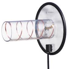
Having completed most of the accounting system conversion, I had some time to return to the development of the Land-mobile Satellite Network Simulator (LMSNS). Specifically, I have manged to create a set of object classes that implement models for monofilar helical antennas operating in the first mode of the axial condition. Such antennas look much like that shown below.  The objective of this activity was to work out the object/class designs for the antenna portion of the software design, but helical antennas are common among satellite systems. The software can now create an antenna object whose subclass is a helix antenna. Based upon a design frequency and number of turns in the helix an object will be created along with all of the helix parameters. I have included methods to calculate the gain pattern for the helix and a sample result is plotted below. The plot shows the hemispherical gain pattern for a 17-turn and 4-turn helix each designed for 150 MHz operation. Gain patterns at 170 MHz are also shown. Measured patterns would likely show a drop in gain at 170 MHz, but this is a consequence of the models accuracy. The models were taken from “Antennas for All Applications”, by John Kraus and Ronald Marhefka. This develops the software basis for which other antenna classes may be developed for the LMSNS. One activity will be to implement the coordinate transformations that covert a direction to a earth terminal location to azimuth and elevation angles relative to the antenna main axis.


Satellite Simulator continue to make progress…

/ May 13th, 2009 / Comments Off on Satellite Simulator continue to make progress…

We are making progress on the development of Questiny’s Land-mobile Satellite Network Simulator (LMSNS). We have just completed its ability to download two-line elements from NORAD, propagate those elements to a common time, and predict the satellite locations. Below is a plot of the satellite orbits for 200 minutes. The four satellite planes are clearly visible.

In addition, our tool can now estimate the visibility of the satellite relative to a location on the earth. We have taken a location of 0.0 degrees N, 0.0 degrees E, and determined the elevation angle to each of the satellites. This location was chosen as the equator provides the most pronounced gaps for LEO constellations. The satellites are spaced the farthest apart along the equator, so we felt that it might be a most interesting case. The orbit locations were calculated every 2 mintues throughout the 200 minute simulation duration. Calculating these elevation angles that were above 5 degrees and summing the number of such satellite at each time period results in the number of visible satellites. We have plotted this in the graph below.

The interesting thing about this plot is that most of the time an earth terminal will have good visibility to the constellation, but it is not without gaps. We see that there is about a 2 minute gap around 82 minutes into the simulation, and a one minute gap around 19 minutes into the simulation. That means using Orbcomm for continuous back-haul communications is difficult in the current constellation. The reasons for this gap may be due to an incomplete constellation. If so, these gaps would disappear when the constellation is fully populated. In addition to the technical algorithms and software, wer are making progress on the GUI as well. We currently have a mock-up of the GUI, and are developing a working prototype within Matlab. We hope to have furhter progress on it this week.

Radio Propagation Modeling

/ January 30th, 2009 / Comments Off on Radio Propagation Modeling

On January 10th, Questiny received notification from SPAWAR that they would exercise the option on our Phase I SBIR on Land-mobile Satellite Communications: Improved Mathematical Methods for Stressed Users. In addition, on January 25, 2009 we submitted our Phase II proposal to SPAWAR for consideration. Together, the Phase I Option and the Phase II effort will prototype an advanced discrete event satellite communications simulator for US military UHF satellite communications. This simulator employs our advances in land-mobile satellite channel models, and our advanced design in discrete-event radio propagation modeling. When completed, this tool will provide a comprehensive US military communications planning tool.