Posts Tagged ‘radio propagation modeling’

For LightSquared, “And now the end is near,…”

/ February 16th, 2012 / Comments Off on For LightSquared, “And now the end is near,…”

To quote a famous Frank Sinatra song, “the end is near.”  At least it appears that way for LightSquared.  On February 14, the NTIA released a letter to the FCC stating, “We conclude at this time that there are no mitigation strategies that both solve the interference issues and provide LightSquared with an adequate commercial network deployment.”  Responding to that letter, today the FCC released a spoken statement that said, “The International Bureau of the Commission is proposing to (1) vacate the Conditional Waiver Order, and (2) suspend indefinitely LightSquared’s Ancillary Terrestrial Component authority to an extent consistent with the NTIA letter.”  In short, LightSquared’s access to the spectrum has been denied.  It’s likely that from this point forward, the lawyers will be the primary recipient of funds.

This is a sad result, although predictable.  As LightSquared heads for bankruptcy  or buyout (the fourth in this Companies history, if I count correctly), it’s appropriate to reflect.  While nearing the end, the aftermath of LightSquared’s attempts will be long.  However, I am hopeful that some positive change might result.  While true that politics became the dominate force in this debate, I consider that actually a plus since politics often arises when so many are affected by the outcome.  As I have said many times, the outcome of this could be predicted by the number of voters that had GPS units compared to the voters with LightSquared handsets.  But in a larger context, this whole issue has raised the awareness of many to our reliance on GPS, its vulnerability; the intense battle for spectrum to support our insatiable appetite for wireless devices; and the complexities of dealing with spectrum regulation (there were at least five agencies involved in this debate excluding Congress, Dept. of Transportation, NTIA, FCC, DoD, NPEF, and the FAA to name a few).  It is my hope that the result of this will create an awareness that GPS has become a critical public service worthy of strengthened policy and legislation protecting its civilian use.  It is also my hope, that the FCC and DoD can better their spectrum management to address situations where manufacturers that ignore the technical parameters in adjacent spectrum cannot seek “protection in numbers”, and the FCC begins to monitor the circumstances that foster spectrum squatting.

I may in a minority, but I actually think the FCC got more right with this than wrong.  Nothing about the January 2011 waiver required a change in the technical parameters for LightSquared, so in my mind, it did not require a Notice for Proposed Rule Making (NPRM) by the FCC.  However, there are those such as Scott Pace, Director of Space Policy at George Washington University, that disagree believing that such a widespread deployment of terrestrial capacity was a change in the spectrum use.  It is an argument, and one that LightSquared bet on – at least one way.  However, the GPS community bet the opposite way.  Any Company deploying a Ancillary Terrestrial Component in this frequency range will create the issues raised by the LightSquared testing.  It’s just a matter of how widespread.

My last hope for a positive outcome of this drama, is the highlighting of the support for space technology and space communications.  LightSquared may have been a thinly veiled attempt at auction free wireless spectrum (hardly free by Falcon’s accounting at the moment), but it was a satellite system too; and in that it was an attempt to create a economically  viable hybrid network of satellite and terrestrial capacity.  That in itself is a noble goal in that it would bring a national service to rural communities and provide a competitive alternative to the wireless oligarchy emerging in the US.  The good news on that front is that while LightSquared may be at its end, EchoStar is coming, ViaSat has launched, and either of them have a better chance at success.  To quote Mr. Churchill, “This is not the beginning of the end, but it is the end of the beginning!”

Legislation Adds Further Delays to LightSquared

/ January 6th, 2012 / Comments Off on Legislation Adds Further Delays to LightSquared

The “National Defense Authorization Act for Fiscal Year 2012” signed by President Obama signed at the end of 2011 included a section (Title IX, Subtitle B, Section 911) that directed that ” The Federal Communications Commission shall not lift the conditions imposed on commercial terrestrial operations in the Order and Authorization adopted on January 26, 2011 (DA 11–133), or otherwise permit such perations, until the Commission has resolved concerns of widespread harmful interference by such commercial terrestrial operations to covered GPS devices.”  In other words, LightSquared is prohibited from deploying their terrestrial base stations until it is determined that there are no impacts to “covered GPS devices” (i.e., military GPS receivers).  The Act goes on to order the Secretary of Defense to report to Congress every 90 days the results of testing that t if Military GPS receivers are effected by LightSquared operations.  This report is to be delivered to Congress every 90 days for two years.  Ouch!

Such legislation has some dire consequences for LightSquared.  Some background may be needed.  First, the FCC provides no protection for commercial receivers of any kind (other than to limit their own radiation through Type A and Type B certifications).  If a manufacturer builds a poor receiver that does not function, too bad for that manufacturer.  Also, there are no protections for commercial civilian GPS receivers.   the fact is that the GPS system is a DoD satellite navigation system, designed and operated by and for the military.  As far as I know, no federal agency or legislation protects the civilian use of GPS, and no tax dollars outside of the DoD’s budget goes to operate or maintain GPS.  If the DoD saw fit to turn GPS off, they could do so, and commercial users have no recourse.  No one believes such a thing would happen, but I understand that it is fully within the DoD’s right to do so.  This is why the Defense Authorization Act can only address “covered GPS devices.”  However, this creates quite a problem for LightSquared.

LightSquared has taken several steps to mitigate the interference to commercial GPS devices.  They have offered to reduce their power levels, operate on limited carriers for a period of time for manufacturers to improve their receivers and time for these improved receivers to diffuse into the market.  In addition, LightSquared has developed new filters to assist commercial precision GPS receivers that operate within the LightSquared spectrum.  All of these are the actions of a “good spectrum neighbor”, but unfortunately, they do not apply to the Military.  The Military has, and now must, conduct their own testing of these devices.  This means that LightSquared has to protect the US Military use of GPS before Congress will allow the FCC to license LightSquared. The consequence to LightSquared is that this will take time, and time is something I believe LightSquared is running short of.

It’s been reported that LightSquared needs additional funding to continue operations, and that these financial needs are becoming immediate.  If the Military can determine that LightSquared will not interfere with their receivers, then LightSquare might be granted a license to operate, paving the way for more funding.  But how long will this take?  I speculate that it could take the DoD more than 90 days just to identify the organizations impacted and the GPS equipment that should be tested.  Once that is decided, units would have to be procured and tested under conditions the US Military users accept.  To me, this sounds like a very long process.

For planning, let’s say the results are that there are some impacts the Military GPS devices, but they can be fixed with modifications to the GPS receivers (all big ifs).  Such modifications will have to conform to military procurement.  Military procurements take much longer civilian manufacturing.  Furthermore, such procurements are much more expensive, and many of the GPS devices are within classified equipment.  In times of declining defense budgets, where would the DoD find such money?  Under this scenario, LightSquared has limited options to mitigate the impacts and reduce any delays.

LightSquared might have a trump card, and I don’t know why they have not played it so far.  The card is this.  If GPS is so critical to Military Operations, then why can a civilian system affect its performance when it is operating well within its technical parameters and on an adjacent spectrum?  Doesn’t this mean that GPS is extremely vulnerable, and needs to be fixed anyway?  That may be happening.  I understand that GPS 3/R, the latest GPS replacement satellites, offers improved protection for Military users.  However, that still doesn’t ease the delay for LightSquared.  In the end, the “tyranny of the clock” may be working against LightSquared.

I think it sad if LightSquared should succumb to the business pressure resulting from these delays.  LightSquared is the first real attempt at a hybrid satellite-terrestrial communications system.  It is my opinion that such systems are needed if a viable communications satellite industry continue in the United States.  Such a system does not have to operate on spectrum adjacent to GPS, but it will need access to spectrum amenable to dual terrestrial and satellite operation.

SBIR Land-mobile SATCOM Simulator Quarterly Status

/ January 23rd, 2010 / Comments Off on SBIR Land-mobile SATCOM Simulator Quarterly Status

Yesterday we completed our first quarterly technical review with the Navy SPAWAR on the development of our Land-Mobile SATCOM Network Simulator (LMSNS).  The review went very well, and the Navy was impressed with the progress we have made on the software design and development.  They were especially impressed with the degree of flexibility that our performance simulator will provide while at the same time allowing users to build up models over time, adding complexity as they uncover more details of the system they are trying to simulate.  This is important to them as many of the performance modeling tools they have require complete inputs to run.  These complete inputs can mean hundreds or thousands of entries into the simulator.  This is fine when you know them, but often you do not, and users want a simulator that can run with partial or simple inputs.  Further, simple models can provide insight into the effects of various changes that complex models may hide.  Such features and capabilities seemed to find a favorable ear with the Navy.  Next quarter, we continue to build our simulator.  We are rapidly closing on the design, and coding will begin in earnest in a week or so.  If you have interests or stories regarding satellite or wireless performance simulations, we would love to hear from you.  Please post any comments and stories.

Satellite Network Simulator

/ June 5th, 2009 / Comments Off on Satellite Network Simulator

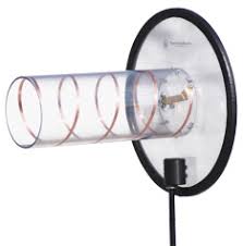
Having completed most of the accounting system conversion, I had some time to return to the development of the Land-mobile Satellite Network Simulator (LMSNS). Specifically, I have manged to create a set of object classes that implement models for monofilar helical antennas operating in the first mode of the axial condition. Such antennas look much like that shown below.  The objective of this activity was to work out the object/class designs for the antenna portion of the software design, but helical antennas are common among satellite systems. The software can now create an antenna object whose subclass is a helix antenna. Based upon a design frequency and number of turns in the helix an object will be created along with all of the helix parameters. I have included methods to calculate the gain pattern for the helix and a sample result is plotted below. The plot shows the hemispherical gain pattern for a 17-turn and 4-turn helix each designed for 150 MHz operation. Gain patterns at 170 MHz are also shown. Measured patterns would likely show a drop in gain at 170 MHz, but this is a consequence of the models accuracy. The models were taken from “Antennas for All Applications”, by John Kraus and Ronald Marhefka. This develops the software basis for which other antenna classes may be developed for the LMSNS. One activity will be to implement the coordinate transformations that covert a direction to a earth terminal location to azimuth and elevation angles relative to the antenna main axis.


Radio Propagation Modeling

/ January 30th, 2009 / Comments Off on Radio Propagation Modeling

On January 10th, Questiny received notification from SPAWAR that they would exercise the option on our Phase I SBIR on Land-mobile Satellite Communications: Improved Mathematical Methods for Stressed Users. In addition, on January 25, 2009 we submitted our Phase II proposal to SPAWAR for consideration. Together, the Phase I Option and the Phase II effort will prototype an advanced discrete event satellite communications simulator for US military UHF satellite communications. This simulator employs our advances in land-mobile satellite channel models, and our advanced design in discrete-event radio propagation modeling. When completed, this tool will provide a comprehensive US military communications planning tool.